


The Bricotte
Randonnée pédestre
Duration
Distance
Elevation gain
This 5-stage, 77-kilometre loop crosses the border twice before reaching the starting point in Maîche (in France). You’ll cross some remarkable tourist sites, such as the Echelles de la Mort (Ladders of Death), and discover the riches of the local heritage: Lake Biaufond and its submerged border marker, the glacial combe of the Louisots, the Yellow Gentian, as well as buildings that bear witness to the cultural and historical heritage of the region, such as the old tacot line leading from Maîche to Morteau and the tuyé farms. The “bricottiers” smuggled goods for subsistence and were experts at hiding to avoid being caught by customs officials.
Highlights
- The Cendrée lookout
- The ladders of death
- The lake and combe of Biaufond
Access
You can get to Maiche from Pontarlier, Morteau or Montbéliard station on the MOBIGO line : https://www.viamobigo.fr/ftp/document/mobigo-lr206-pontarlier-montbeliard.pdf
Starting point - Maîche

Maîche Au Bois de la Biche (France)
Duration
Distance
Elevation gain
The route begins at the Maiche Tourist Office, passing in front of Château Montalembert and the grounds of Château du Désert. It then climbs towards the Saint Michel hill to leave the town. You then follow the remains of the “tacot” railway line that leads to the Combe Saint Pierre via Charquemont. At the end of the route, the “La Cendrée” lookout, named after the colour of the rock, offers a panoramic view over the Vallée de la Mort, which you will reach the next day after the stage at “Bois de la Biche”.
To discover along the way
- Le Château Montalembert 16ème et 17ème siècle
- Les vestiges de la ligne du “Tacot” fermée en 1952
- La Chapelle Saint Roch et le cimetière des Bossus de Charquemont ou étaient enterrés les pestiférés dans les années 1630
- La combe Saint-Pierre et ses activités 4 saisons
A few steps from the trail

Au Bois de la Biche (France) Les Bois (Switzerland)
Duration
Distance
Elevation gain
This stage makes you aware of the dangers faced by smugglers when descending the ladders of death and of the austere atmosphere of this valley, which you follow all the way to Lake Biaufond. This stopover point for many migratory birds is very restful, before continuing on the Swiss side and climbing back up to “Les Bois”. The stage normally stops in this village, but the hotel is closed and you will have to continue to the Auberge de la Légende in Le Boéchet via the railway line and return to Les Bois the next day. Free transport to and from the village on request from reservation@lalegende.ch
To discover along the way
- Les Échelles de la Mort
- Le Lac de Biaufond, et le barrage du refrain
- Les ruines du moulin de la mort

Les Bois Maison Monsieur (Switzerland)
Duration
Distance
Elevation gain
Back at “Aux Bois”, continue towards “La Ferrière” and then down to Maison Monsieur, where you can cross the Doubs in a boat. Before reaching Maison Monsieur, stop off at the Cul des Prés lake, which has the unusual feature of storing water and gradually releasing it, then at the Roche Guillaume viewpoint. Maison Monsieur, on the banks of the Doubs, is an idyllic green setting that seems timeless.
To discover along the way
- Le lac du “Cul des Prés”
- Le point de vue de la “Roche Guillaume”
- Le pavillon des sonneurs à Maison Monsieur
A few steps from the trail
-
Point de vue “Le Bichon” (1/4 d'heures en plus)

Maison Monsieur (Switzerland) Bonnétage (France)
Duration
Distance
Elevation gain
From “Maison Monsieur” you follow the Doubs to cross the border over the Eiffel-style Rasse bridge. A long climb leads up to the village of Fournet-Blancheroche. On the plateau, the glacial combe of the Louisots is characteristic of the Jura relief, a sensitive and fragile environment with specific limestone flora such as orchids and carline. After a final view of the Doubs valley from the Philiberts belvedere, continue on down to Le Russey and Bonnétage.
To discover along the way
- La ferme des Guinots dont le tuyé est un des plus grands du territoire.
A few steps from the trail

Bonnétage Maîche (France)
Duration
Distance
Elevation gain
This is the last stage on the way to Maîche, passing through the Creugnots peat bog, a Natura 2000 site with special vegetation including the drosera, a carnivorous plant. You pass through Frambouhans to reach the Faux-Verger and its 360-degree panorama. The descent to Maîche follows a picturesque rocky ridge with several small viewpoints.
To discover along the way
- Point de vue Le Faux Verger
- La tourbière des Creugnots
- Les dolines
End point - Maîche
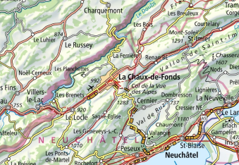
Map
Markings

Common markings along the entire trail
In France
Régional GR® 5


In Switzerland

View map
Download the GPX file
Download the game guide