


The Orlogeur
Randonnée pédestre
Duration
Distance
Elevation gain
Follow in the footsteps of l’Orlogeur over 5 stages between Morteau (France) and La Chaux-de-Fonds (Switzerland). You’ll discover exceptional natural sites, museums filled with the wealth of local watchmaking expertise, and the region’s cultural and architectural heritage.
The route takes in the Saut du Doubs, and along the way you’ll see Comtois farms, follow the border markers, and end up in the watchmaking town of Le Locle and La Chaux-de-Fonds, both UNESCO World Heritage Sites.
The clockmaker travelled from farm to farm repairing and maintaining the family clock. This itinerant profession lent itself particularly well to the smuggling of more or less expensive parts.
Highlights
- Watchmaking museums
- The border markers
- The Saut du Doubs
- The town’s watchmaking heritage is a unesco World Heritage Site.
Access
The return journey can be made by train along the watchmakers’ line :
- Morteau station (France) :
https://www.sncf-voyageurs.com/fr/voyagez-avec-nous/horaires-et-itineraires/ - Chaux-de-Fonds station (Suisse) :
www.cff.
Stage 3 ends with a mini-cruise in the Doubs basin : http://www.nlb.ch/index.php/fr/
Starting point - Morteau

Morteau Vieux Châteleu (France)
Duration
Distance
Elevation gain
This first stage begins at the Musée de l’Horlogerie du Haut-Doubs in Morteau. You then cross the Morteau plain, the remains of a Palaeolithic lake, in the middle of which the waters of the Doubs lazily flow. The ascent begins at the bottom of a small valley, reaches the village of Derrière le Mont and continues through the countryside to reach the Vieux Châteleu farmhouse inn, closely linked to the story of the Resistance fighter Michel HOLLARD “the man who saved London “485 Please note that there are no refreshments along the route.
To discover along the way
- Le paleolac de Morteau
- Le Château Pertusier de style renaissance du 16ème siècle
- L’histoire de Michel Hollard, “l’homme qui a sauvé Londres” , résistant fondateur du réseau AGIR
A few steps from the trail
-
L’Eglise Notre dame de l’assomption de Morteau 15ème siècle (500m)
-
Le Point de vue du Châteleu (sommet culminant à 1302) (1500m)

Vieux Châteleu Sur la Roche (France)
Duration
Distance
Elevation gain
After leaving “Vieux Châteleu”, you pass through “Les Cernoniers” to discover the Chapelle Sainte-Anne and the old tuyé farmhouses, typical of the Haut-Doubs region. The trail then heads towards “Meix Lagor” and joins the Gardot Nordic site. There is a picnic room open from April to October and picnic tables outside. You then walk along the border, where stone boundary stones mark the boundary between the two countries. After the “Meix-Musy” viewpoint, the path finally takes you to the hamlet of “Sur la Roche”, where this second stage comes to an end.

Sur la Roche (France) Les Brenets (Switzerland)
Duration
Distance
Elevation gain
You descend to Villers le Lac on the GR5/GTJ. The route then runs alongside Lac de Chaillexon, overlooking the Doubs basins and reaching the Saut du Doubs site. From the lookouts you can see the impressive waterfall, even at low water. Self-catering room on site. Please note: to reach the end of the stage, you must take the NLB boat, on the Swiss side, located after the footbridge (last departure around 5 p.m. in high season; check with the company for timetables and sailing conditions).
To discover along the way
- Les bassins et le Saut du Doubs
- Sur le trajet en bateau vous pouvez apercevoir la grotte du Roi de Prusse et les impressionnantes falaises calcaires qui enserrent la rivière
A few steps from the trail

Les Brenets Le Locle (Switzerland)
Duration
Distance
Elevation gain
From Le Brenets, you head back in the opposite direction along the ponds. After the Saut-du-Doubs, a fairly steep but pleasant climb through the forest takes you to the pastures of the “endroits”. Once you’ve completed this climb, after a visit to the Le Locle watchmaking museum in the “château des monts” estate, all you have to do is head back down to the town of Le Locle and its watchmaking town planning, a UNESCO World Heritage Site. Don’t miss the exotic museum: https://exomusee.ch/home-e/ Please note that there are no refreshment facilities along the route.
To discover along the way
- Le musée de l’horlogerie du Locle au château des Monts avec ses fabuleux automates miniatures.
- Au locle, à l’image de la mosaïque monumentale qui orne le fronton de l’hôtel de ville, vous pouvez déambuler dans les rues pour découvrir l'exomusée en plein air qui compte aujourd'hui une trentaine d'œuvres de street art, sur le thème du temps et de l’horlogerie.Un plan est disponible à l'office du tourisme
A few steps from the trail
-
La tour Jurgenson aux Brenets (3000m)
-
Les Moulins souterrains au Col des Roches (3000m)

Le Locle la Chaux-de-Fonds (Switzerland)
Duration
Distance
Elevation gain
The path follows the first stage of the revolutionary route taken by the inhabitants of the Neuchâtel mountains in 1848 to overthrow the government in Neuchâtel. The trail leads back down to the town of La Chaux-de-Fonds, whose watchmaking town planning is also a UNESCO World Heritage Site. You can visit the international watchmaking museum and the watchmaking town planning area to understand how this know-how was implemented and its repercussions on architecture. Return to Morteau by train.
To discover along the way
- L’urbanisme horloger
- Le musée international d’horlogerie
- L’espace de l’urbanisme horloger
A few steps from the trail
-
Le point de vue sur le lac des Morons aux planchettes (1500m)
-
La villa Turque du Le corbusier à la Chaux-de-fonds rue du Doubs (900m)
-
La Tour espacité au centre ville qui offre une vue panoramique sur la ville du haut de ses 60 mètres.
End point - la Chaux-de-Fonds
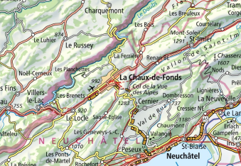
Map
Markings

Common markings along the entire trail
In France
Regional GR® 5


In Switzerland

View map
Download the GPX file
Download the game guide